So I will be doing the FBT ate the end of May this year. It will be the 5 day 5 night version. Is there anyone here who has done it recently? I am the kind of hiker who does way too much prep, but for me that is kind of part of the Hike.
I have a few questions:
Does anyone have a Topographical map of the area? I went to Map Studio, but can’t get any help from them. There is a DVD with all of South Africa on Topo, but for a few sheets I don’t want to spend 500R.
Getting back to the starting point. I will be starting at Ceylon Forest Station, and ending in Graskop. Any ideas on getting back to my car?
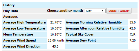
Expected weather: Seems to be getting cooler that time of year and less rain.
Drinking water on route. As far as I can find, the huts have drinkable water, but on on the trail is the water in the streams drinkable?
My parents live in the area (Graskop) and I’m bummed that I haven’t done the Fanie Botha either. You can perhaps have a look at “Avenza Maps” as well, it’s an app than has a database of contour maps available (most of the South African maps are available and free). I cannot guarantee that the maps are up to date but it can be a handy backup. The nice thing about the app is that it can show your location on the map so navigation is super easy.
Enjoy the hike, that part of the country is amazing.
Thanks for the tip on Avenza Maps.
I have downloaded the app for PC and Phone. Seems really easy to use. And good to have on the phone.
But as I hike quite old-school I only use Map and compass for Navigation. I wont be taking my smartphone with me. I do have a credit-card sized phone for emergencies. Unfortunately I am not able to get a printable version of the Topo-maps from the app. I have downloaded the correct ones and can view them on the PC but not print them.
Hi Julian, we did the same route during the October-school holiday and used the map that is available online, which was totally sufficient. The trail is well marked and we had no problem with navigation. Make a point of taking the detours - you won’t regret it. Just note that the bathrooms at all the huts are in urgent need of attention, so prepare yourself mentally! But as for the rest: it is still one of the most beautiful routes in South Africa - enjoy!