I see that CapeNature has finally removed the “closed until further notice” banner from the Groot Winterhoek webpage and I am very keen to head up there for a weekend. I would appreciate recommendations for a suggested weekend hike, either arriving late on Friday night or early Saturday morning until Sunday afternoon with overnight in either tent or one of the huts. Thanks in advance.
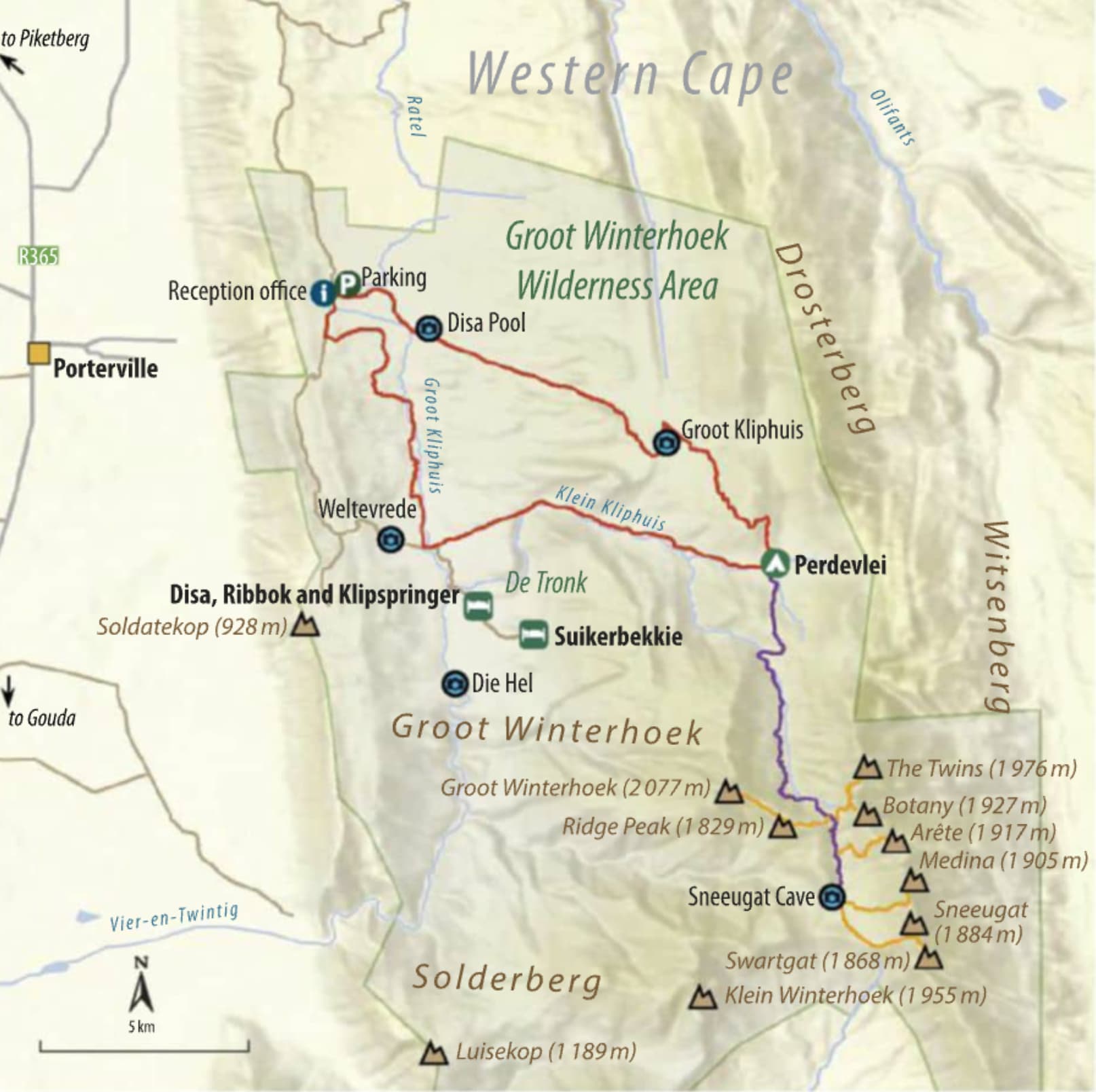
I believe the paths are signposted and navigation is easy. Just a tip on navigation in Groot Winterhoek - the only good maps available are the 1:50000 topographical maps of SA. The trails are however indicated on this map for the area (3319AA Groot Winterhoek).
I use an app called Avenza Maps, where you can download the 1:50000 topographical maps of SA for free use. It even shows your location on the map itself and can take compass bearings, measure and record routes, etc. (not very accurate but handy nonetheless).
PS, the Groot Winterhoek peak is on my to do list, looks like a real adventure (multi day offtrail self navigated). Its a very prominent peak (2077m), hard to miss once you have spotted it.
@ThePeanut yes of course. Its just an idea at this stage, i dont know the area and would probably first go do Die Hel to get a feel if it looks probable or not. I would assume the vegetation is pretty dense, making offtrail endeavours hard. Need some MCSA intel
A friend did it a few years back, so I got his GPX for it. I’ve been meaning to climb it for a while - but its a really difficult peak to get up. Also doesn’t help to live over 1000km away, so I can’t just drive out on a Friday afternoon. As far as I understand, there’s nowhere suitable to camp on the way up the peak, so unless you bivy in the bushes, you basically have to do it in a day from the hut.
My ongoing SA mountain goal is to summit all 24 mountains in SA with at least 1000m topographic prominence - of the 8 I have left, and Groot Winterhoek is the hardest one. Difficult call between it and Buffelshoek for which is the hardest peak on the list - I’ll comment once I’ve done both. At least with Buffelshoek I could camp near the peak to make a relatively comfortable 3 day hike.
Hi Jonathan,
thanks for the feedback. Your ongoing mountain goal sounds amazing - like a really cool mission.
I am eyeing Groot Winterhoek since a long time. I am aware of the camping situation but have no issues with bivy - have done that plenty of times Probably I would attempt it in one day though.
Could you please share the GPX of your friend? Would appreciate it.
Hi @Ghaznavid@Dennis@Wooshness! I’m wondering if any of you ended up doing Groot Winterhoek peak? I’m heading there for a solo mission over the next week or so and will very much appreciate a GPX
I’ll be wild camping so distance from huts not an issue. I’ll likely bivvy near Perdevlei. I have a Forge map for the main trail including Perdevlei, but don’t have a route from there to the peak.
Hi Coffee, I was in Groot Winterhoek in October and did a lot of searching for GPX’s. I never found public GPX’s to the summit of Groot Winterhoek but I will PM you some heat map data which might help. We stuck to the normal paths but here is a Gaia link to our GPX.
Thanks, that’s brilliant! I scoured even the most obscure climbing forums and sub-reddits & also haven’t found anything. The heat map is super helpful, thanks.
Hi @coffeeandkale,
I never made it up yet as the weather turned bad … if you do go, please share the GPX files I am still very keen to explore this area.
Would you mind sending me the heat map as well - heading that way over the weekend and might want to do a summit excursion. Otherwise any camping spot suggestions (not mentioned here) that you’d recommend since you were there recently? Im hoping there’s plenty water all around…
Hi @BKassel lets see if I can help! Since my last post on here I have seen that in Go! Hiking Magazine 2023 (which you can buy it online here) had an article on Groot Winterhoek with a little map showing they reached Groot Winterhoek vie Ridge Peak accessing the mountain from the East side. This is very different to my heatmap data I pulled and matches MCSA routes mentioned online:
Camping spots:
There so many potential spots to camp at Groot Winterhoek. I wouldn’t stress too much about it. But here are some suggestions: Die Hel
If you are happy to camp on the trail, there is a great camping near Die Hel under massive oak trees. Coordinates: -33.07395, 19.09450
From Parking towards Perdevlie Shelter:
Another brilliant spot under oak trees if you going slow on Day 1.
Coordinates: -33.03302, 19.13176
There are also a lot of spots around -33.04876, 19.12164.
Ah yes, I did see the MCSA basic description of when they went to summit so this makes sense. Thank you for this as well as the coordinates! Will probably try to camp somewhere off path, but great to have these as backups depending on where we end up. Heading there tomorrow so much appreciated

 Haven’t been there either…