The 9 peaks challenge has grown in popularity over the years. The premise is simple - stand on the highest summit within each of the 9 provinces of South Africa. As they follow a reasonably direct line, it isn’t too complicated to string them altogether. I’ve personally done 7 out of 9, with just Limpopo and Mpumalanga to go.
However, one aspect that has always bothered me with this challenge is that a number of peaks on the list don’t even have enough prominence to qualify as “mountains” (7% prominence, 200m minimum definition). Mafadi (KZN and SA high point) only has 75m, Namahadi (Free State) only has 54m and Nooitgedacht (North West) only has about 100m despite being right next to the highest point in the Magaliesberg which has 362m.
A fun variation on this challenge is to switch the province high points for the peaks with the highest topographic prominence in that province. None of the province high points have the most topographic prominence within that province - so it’s an entirely different list.
The list is as follows:
Western Cape: Du Toits Peak 1994m, 1732m prominence
Eastern Cape: Cockscomb 1768m, 1291m prominence
Limpopo: Marakele 2088m, 1061m prominence
Mpumalanga: Mariepskop 1947m, 845m prominence
Northern Cape: Rooiberg 1692m, 797m prominence
Free State: Platberg 2398m, 720m prominence
KZN: Ingeli 2267m, 682m prominence
North West: Pilanesberg 1689m, 554m prominence
Gauteng: Nooitgedacht West 1852m, 362m prominence
People may find the fact that the Drakensberg doesn’t feature once to be odd - the range does have a summit with over 2000m prominence (Thabana Ntlenyana) and one with over 1000m prominence (KwaDuma Parent Peak), but both are in Lesotho. The most prominent peak in the SA Drakensberg is the South Knuckle at Bushman’s Nek, at 3010m with 498m prominence.
*Note: since initially making this post, I have reviewed the satellite data and I am reasonably confident it is now correct. The only change being Marakele as Limpopo’s most prominent mountain - I initially had it as Iron Crown. Notably North West’s second most prominent mountain only has 3m less prominence than Pilanesberg, so that is easily within measurement error, although the survey maps do tend to back up the satellite data on this one.
I like the alternative 9 Peaks. They are arguably easier to access to, perhaps with the exceptions of Cockscomb and Pilanesberg, which being in a big 5 game reserve, could require some interesting permit negotiations.
I’m finally climbing Cockscomb this weekend with an MCSA team. I have been wanting to do that one for years, but as you say, access is a pain to arrange.
North West does have another peak with almost identical prominence - it would be nice if their prominences were the other way around to make the list a bit easier logistically, but when talking about a 3m difference, conclusively determining which is more prominent isn’t easy.
I can’t find any info on Northern Cape’s peak - no clue how hard that could be to access.
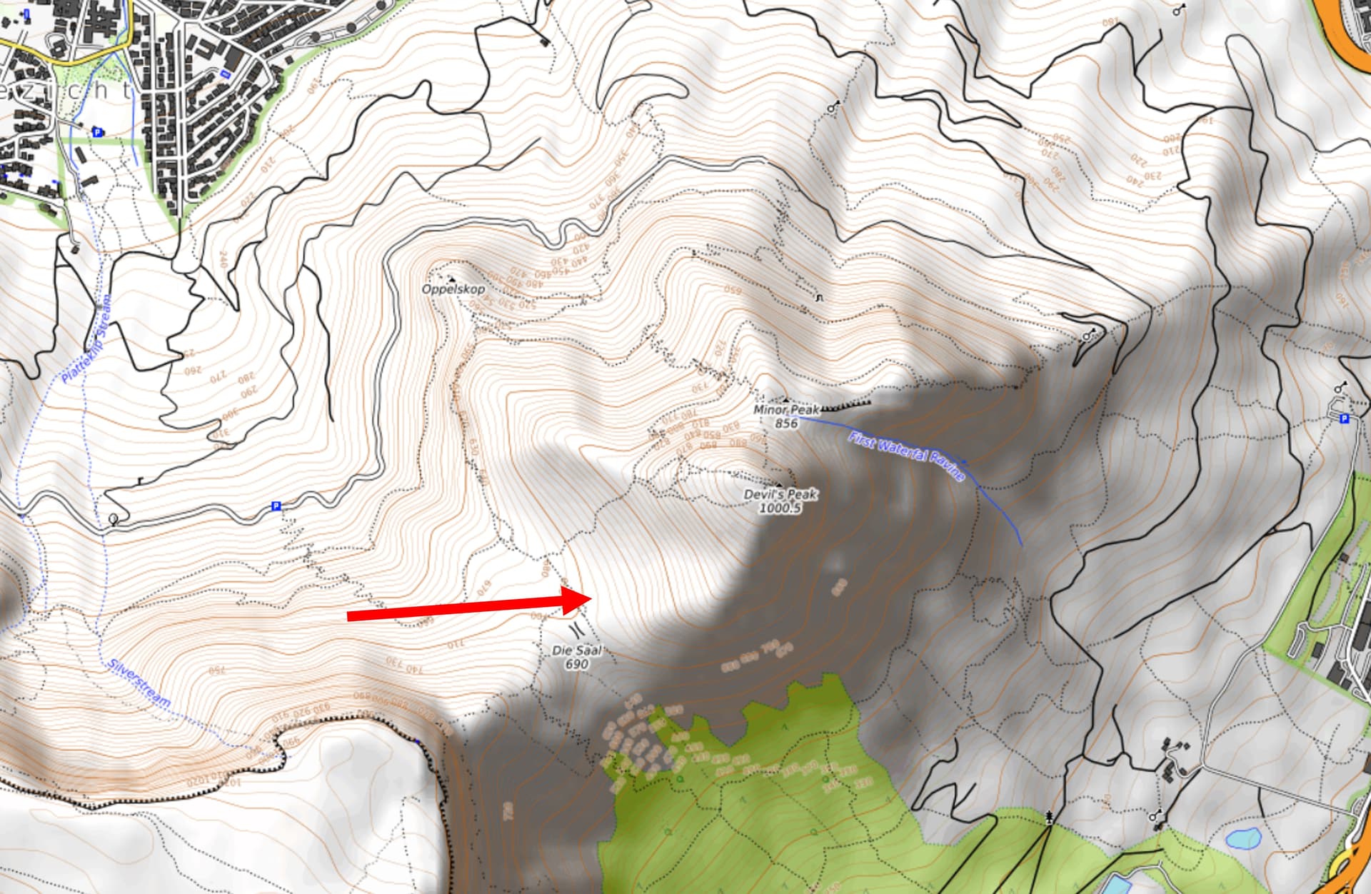
The easiest way of explaining it is with this topo map of Devils Peak in Cape Town. The red arrow points to the lowest contour line that circles the entire peak and within which there is no higher summit. You can see the ring immediately below it includes the higher peak of Table Mountain. Thus the point by this arrow is the key saddle for Devils Peak, with Table Mountain as its parent peak, and its topographic prominence is the difference between this saddle, at just above 700m, and the summit at about 1000m - giving it a prominence of approximately 300m (Peak Bagger has it at 297m).
This is a great idea. How about a top 10 highest prominence peaks in the Western cape?
How did you filter through the data to find these? Manually or is there a list somewhere?
My list of every mountain in SA with at least 1000m topographic prominence is also posted on this site - see the following link:
The list is more or less in order of prominence. The Western Cape top 10 and SA top 10 are almost identical, just with Cockscomb or Mannetjiesberg depending on which one was looking for.
I’ve been working through this list for a while, although my progress has slowed a lot recently after initially getting through the first half of the list rather quickly. I just need six more, all of which are in the Western Cape. Tierberg, Pilaarkop, Groot-Winterhoek, Keeromsberg, Grootberg and Misty Point to go. I also need to tag the high point around 30km from Pilaarkop, which some maps show as higher than Pilaarkop and thus would replace Pilaarkop on the list if it is higher. Not that I need an excuse to go and climb an extra mountain!
haha I found that post just after I left this comment. Thanks man. That’s some great work!
I think there’s definitely scope for a “hit-list” of peaks in the Western Cape that has some sort of mountaineering aspect to it. The prominence list you have there definitely sets the right tone.
Some thought needs to go into getting peaks like Towerkop into the list since you need to actually rope up to get to the summit (even though it’s lower than Seweweeks poort). Or Tafelberg in the Cederberg since the summit is also challenging to get up.
I don’t know, I’m just spitballing here but I’m sure people will be quick to throw in some rad peaks into the hat
Incidentally Tafelberg is the 25th most prominent mountain in SA, so the most prominent mountain without 1000m.
Any hitlist is subjective. Some of SA’s most prominent mountains aren’t that interesting - Bokkeveld Sneeukop and Sebrakop being notable examples. Some of the super obscure peaks have been really cool - e.g. Mannetjiesberg and Saronsberg. The list notably doesn’t have any Drakensberg peaks - there are two in the range with over 1000m, but both are in Lesotho. Cathedral Peak and Cleft Peak are some of SA’s most impressive peaks, though.
I’m keen to get those subjective opinions though! Also worth exploring would be an option where you can hit a number of epic peaks in a 3 or 4 day hike. Like the Hex traverse or Du Toits peak to Deception peak or Goudini Sneeukop…
Anyways. This is probably something to put in a new thread.
How did you calculate the prominence of Marakele and Iron Crown?
On PeakBagger, I see 1008m for Marakele and 1045m for Iron Crown making Iron Crown more prominent (and I can verify the calculation based on the key col they selected); on WorldRibus, I see 1017m for Marakele and 1056m for Iron Crown making Iron Crown more prominent again (no way to check their calculation). Another possible peak is Blouberg, 1014m on PeakBagger and 1021m on WorldRibus; still less prominent than Iron Crown. This is why I chose Iron Crown so for the PeakBagger list above.
I see you have the same elevation for Marakele as PeakBagger and WorkdRibus. So the difference in prominence calculation must be the elevation and/or location of the key col. What key col did you chose for it and how did you get its elevation?
Which mountain in North-West has 3m less prominence than Pilanesberg?
I looked on the map and could not find a mountain nearly as prominent as Pilanesberg. I would be interested to know so I do some more research myself too on its prominence.
Practically:
Have you eventually made it to Cockscomb (you have not logged it on PeakBagger)?
Have you found a way to reach the top of Pilanesberg?
I may consider linking some in a future work trip to SA. Platberg and Namahadi seems doable in a weekend from Joburg. Ingeli and Kwa Duma can perhaps be done from Durban in a 3- or 4-day trip. Cockscomb and Murch Point can maybe be done (if all the associated red tape is sorted) in a 3-day trip from Port Elisabeth/Gqeberha.