South Africa's most prominent mountains

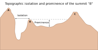
Topographical prominence is a scientific measure for the base-to-top height of a mountain. The easiest way to describe it is - if you flood the earth till that mountain becomes the highest point on its own island, how high would the summit be above sea level.

For example - Everest is already the highest point on its island, so its prominence is its height.

By contrast - Lions Head is far from being the highest point on its own island, so we would have to flood the earth (figuratively speaking) till the saddle between Lions Head and Table Mountain was at sea level, and thus the height difference between that saddle and the summit would be Lions Head’s topographical prominence.

Here’s a diagram off Wikipedia that illustrates it very well:
image

A full survey of the every summit on earth with at lease 100m prominence was conducted based on satellite data and posted online - being a 300+MB text file, link available if anyone would like to look at it (not conducted by me). I took this data to create a list of every mountain in South Africa - with a mountain being defined as a summit with:

  • At least 200m prominence
  • At least 7% prominence relevant to height
  • A height of at least 500m

Naturally definitions are subjective, the UK uses 1000ft (305m) as a minimum height, but seeing as SA’s highest summit is 2km higher than the UK’s, 500m seems more reasonable. 7% prominence is the requirement used in the Himalaya, and a 200m minimum was included to reduce the number of small hills that make the list.

The result was a list of over 2500 mountains in SA. This data is simply a GPS co-ordinate, height and prominence - so anyone who would like to help populate peak names is welcome to help me with this. Many probably don’t have names - and who doesn’t love to climb “beacon 381” in the middle of nowhere?

Of these mountains, 24 had over 1000m prominence. Incidentally both Drakensberg summits with 1000m prominence are actually in Lesotho, thus leaving the Western Cape with 18, Eastern Cape with 3 and Limpopo with 3. The other 6 provinces have none.

After hours of work researching this, I managed to find the names of all 24. The list is as follows, in order of prominence, height listed as the final number:
Du Toits Peak (Du Toitsberge, Western Cape) 1974m
Seweweekspoort (Klein Swaartberg, Western Cape) 2303m
Matroosberg (Hex River Mountains, Western Cape) 2232m
Sebrakop (Piketberg Mountains, Western Cape) 1446m
Tierberg (name uncertain, beacon 53 on map) (Swaartberg Mountains, Western Cape) 2130m
Cockscomb (Baviaanskloof Wilderness Area, Eastern Cape) 1722m
Blesberg (Swaartberg Mountains, Western Cape) 2069m
Pilaarkop - name uncertain (Riviersonderendberge, Western Cape) 1665m
Groot-Winterhoek Peak (Winterhoek Mountains, Western Cape) 2037m
Keeromsberg (Kwadousberge, Western Cape) 2056m
Mannetjiesberg (Kammanassie Mountains, Western Cape) 1935m
Sneeuberg (Cederberg, Western Cape) 1979m
Grootberg (Grootvadersbosch/Boosmansbos Wilderness Area, Western Cape) 1603m
Sneeukop (Skurweberg, Western Cape) 2054m
Buffelshoek (Hex River Mountains, Western Cape) 2059m
Marakele Peak, name uncertain, Beacon 25 (Groothoek, Limpopo) 2135m
McLear’s Beacon/Table Mountain (Cape Town, Western Cape) 1077m
Iron Crown (Wolkberg, Limpopo) 2121m
Groot-Winterberg Mountain (Groot-Winterberg, Eastern Cape) 2369m
Ga-Monnaasenamoriri (Blouberg, Limpopo) 2046m
Misty Point (also known as Dassieshoek Peak) (Leeu Rivier Berg, Western Cape) 1698m
Roodezandberg/Saronsberg (Groot-Winterhoek Mountains, Western Cape) 1473m
Compassberg (Sneeuberge, Eastern Cape) 2502m
Simonsberg (can’t find a range name, its basically free standing, Western Cape), 1399m

Naturally I have now embarked on the rather arbitrary task of trying to summit every mountain in SA with at least 1km prominence. I did a recent Western Cape trip to get the ball rolling, with 3 of them successfully summited - Du Toits, Matroosberg and McLear’s Beacon. Writeups on those 3 will follow soon. Hopefully next up - the 3 in Limpopo, although access to two of them is proving tricky.

7 Likes

That’s a lekker list of peaks to bag!

We will have to team up on some of them :grinning:

What I have found awesome about this list is that I hadn’t heard of most of these peaks before I started this process. I had only known about Matroosberg for about 3 weeks when I stood on the summit - and while most of the hike was uninteresting, that final 2km to the summit was absolutely spectacular, and made the entire hike worthwhile. Groothoek Kloof is one of the most spectacular gullies I’ve ever seen. It (Matroosberg, not Groothoek Kloof) would make a great beginners route, easy ground at a fair gradient, with a great view at the top.

The Limpopo ones also look great. Iron Crown (really Wolkberg in general) has been on my to-do list for years, but Marakele is a park I had never heard of. Looks amazing, although I am still trying to confirm if unguided hiking is allowed there.

1 Like

@Ghaznavid a mighty undertaking, and great to be finding new peaks through a sidedoor, or backdoor or whatever. I climbed Cockscomb yonks back, some stunning geology there. We were just in Wolkberg now, October, sooo much rain, felt like Spongebob Wetpants by day 3…

3 Likes

@Carl sounds epic!

As Mother Abbess sang in the Sound of Music - Climb Every Mountain. With roughly 317k of them globally (by my definition, that is), that would require just over 14 a day for 60 years - so let’s rephrase that as “climb as many mountains as you can”.

Fun Fact: the highest concentration of ultra-prominence mountains (1500+m) is in British Columbia, Canada. They have 103 of them. For context, Africa only has 85, 2 of which are in SA (Du Toit and Seweweekspoort).

Hi Ghaznavid, sounds like you did Matroosberg from the wrong side. The hikers way is up from the De Doorns side. A lot more beautiful and interesting. There are amazing peaks in the Hex Valley Mountains.

1 Like

@Douweg that would make sense. I’m not sure how access works from the De Doorns side. It was my rest day between day hiking Du Toits and doing a 3 day Hex Traverse hike, hence the choice of route for the day. Please provide more info on the hikes from the De Doorns side, especially access.

The Hex is by far the most impressive mountain range I’ve seen in the Cape, I definitely need to explore it more. Naturally I need to explore other ranges in the area - just to ensure I have sufficient appropriate audit evidence to support my conclusion :grin:

I may try to traverse the range from Ceres to Matroosberg at some point. So, aside from needing Buffelshoek to complete this challenge, I definitely have some unfinished business with the Hex Mountains.

@Ghaznavid, you should definitely get in touch. The route starts on the farm of Retief Jordaan (my father-in-law) who knows those mountains like the palm of his hand. He has done through hikes and traverses and kloofs up there that you won’t believe. Probably something similar like the guy who did the 100 passes in the Drakensberg:-) We also do a yearly abseil trip down Groothoek Kloof.

@Douweg next time I’m in the Cape, I will definitely be in touch, sounds amazing!

How hectic is Groothoek Kloof? It has to be one of the most spectacular locations in SA, I can’t see how it wouldn’t be.

@Ghaznavid

Hahaha, I like that, the South of…well, at least you’re a mountaineer and not a “stream forder” that could turn into a very wet job indeed.

Canadia sounds like the place to be for mountain-goats, wonder how NZ stacks up?

So on the subject of access thought I’d share this with you (and all) — In October I was gathering info on Cockscomb/Baviaans for the future, correspondence with MCSA - E.Cape Charman Francois Searle (info@epmcsa.org.za) led to this:

Cockscomb is on private property and permits are available from our club MCSA EP section. Unfortunately we only issue permits when a MCSA club member is part of the group or to official meets of another clubs and organisations we are familiar with.

Land access is can be a very sensitive issue and one needs to be very careful to obtain the right permissions from land owners in order not to spoil it for others. Mountain land access is one of the MCSA’s key objectives.

Well, at least the mountain will be unspoiled.
And now for something completely serious…

Autocorrect for the win :joy:

New Zealand has 10 - which is a lot for such a small country. Incidentally Australia has 4: 1 on the mainland, 1 on Tanzania and 2 on other islands. Contrary to what is commonly advertised as Australia’s highest point, Mawson Peak on Heard Island is actually the highest point in Australia. It has 3 recorded ascents, and isn’t accessible without a scientific reason (it was climbed to study the glaciers on top, which is a convenient excuse). It is an active volcano, but with no recording equipment on the island, and it almost permanently under cloud cover, we actually don’t really know much about it.

Wikipedia has a fairly good list of ultras for each region, so its easy to find. I might post some spreadsheets on here in the next few weeks - there is a list of all 1600 or so ultras globally. The Wikipedia list is missing about 500, and not all of them have names - especially in Antarctica.

I’m a JHB Section Member, which definitely made access to Du Toits a lot easier, and no doubt will help with many others. Much like Jon Snow, I know nothing about Cockscomb, so still a lot of research before I set out to climb it. This project will take years to complete. Admittedly I could probably do them all in a 6 week period - but I won’t have a window like that to do them. Also, I see no reason to rush through the list - plenty of good hiking and exploration to do. I did the first 3 over 8 days, with a lot of hiking in the middle. I will writeup my 8 peaks in 8 days soon.

I don’t fully understand this system of measuring the prominence. There is surely a flaw in the system if none of the Drakensberg peaks qualify. Champagne Castle rises more than 2000 m abouve the surrounding landscape, while various others, like Cleft Peak, The Sentinel, Cathkin Peak and Mponjwane rise at least 1800 m above the surrounding landscape. I did a survey of the most prominenet mountains in SA some years ago, so I can compare. Many of mine are on your list, but others surprise me. And you might have missed one. Have a look at Mosterthoek Twins near Ceres. I also love climbing those high ones - so enjoy it!

Incidentally I was on top of Waaihoek Peak a few weeks ago looking at the Mosterthoek Twins. They look really cool!

Topographical prominence is measured from all angles, not just the most spectacular line. Champagne Castle has 392m prominence - with a key saddle of the top of Apes Pass, and the parent peak will be Mafadi/Makheka. The easiest way to think about it is that you would have to flood earth till the top of Apes Pass is at sea level to get Champagne Castle to be the highest point on its own island, so its topographical prominence is the difference in height between the top of Apes Pass and its summit. If you have a look at the Peak Bagger website, they have prominence and key saddle stats on a very large database of peaks across the world. Their results for Champagne Castle are at Champagne Castle - Peakbagger.com

3 SA Drakensberg 3000m peaks have at least 400m prominence - the South Knuckle has the most (key saddle around Ngwangwane Pass), with South Hodgesons and Cleft being sufficiently close that satelite data isn’t accurate enough to differentiate which has slightly more than the other. The two peaks in the Drakensberg with 1000m prominence are Thabana Ntlenayana (which gets its prominence off Meru in Tanzania) and an unnamed peak near Kwa Duma on the Lesotho side of the Eastern Cape border. Neither is in SA. Thabana Ntlenyana is obviously an ultra-prominence peak as well (incidentally the first ultra I ever did).

Sentinel has a key saddle of the top of the gully between Sentinel and Beacon Buttress - which is around 2900m - its parent peak will be Mont Aux Sources. Mponjwane’s key saddle will be between the escarpment and the peak itself, just off Mponjwane Pass. Neither even has 300m prominence. Not even Monks Cowl has close to 1000m prominence.

The SA side of the Drakensberg actually doesn’t cope well with the 7% prominence on height definition of a mountain. Only 17 summits in SA conclusively qualify as mountains by that definition. Sadly - Giants Castle misses it by a small margin, with Giants Pass as a key saddle. I seem to recall it missing the cut by 11m. Cathkin also misses it by a fair margin, with a fairly obvious key saddle between it and Monks Cowl at around 3000m.

Just a reminder about what prominence is - a scientific measure of a peak’s base-to-top height. It is not subjective.

What it isn’t:

  • an assessment of how spectacular the peak is
  • an assessment of whether a peak is worth climbing

When I was first introduced to topographical prominence, I really didn’t like it. But the more I have worked with it, the more I appreciate how brilliant the concept is.

SA’s most prominent mountain is Du Toits Peak. It isn’t even 2000m above sea level, but it is a really worthwhile climb. By contrast, Mafadi is SA’s highest point, but only has 111m prominence. Of all the country high points in the world with a highest point above 1500m, only Chile and SA have a country high point that isn’t a mountain by the 7% definition. Makheka is the parent peak to Mafadi and is entirely in Lesotho, while Ojos del Salado’s second summit is the highest point in Chile, with the highest point being a short distance away over the border in Argentina.

I am busy planning my next Cape trip to bag some more of these peaks - I’m having difficulty finding how to access the following peaks, if anyone has any information on this, please let me know:

Sneeukop in the Skurweberge, not to be confused with Sneeuberg in the Cederberg.

Roodezandberg near Groot Winterhoek. Cape Nature has confirmed that this isn’t on their land (contrary to what Google Maps says).

If anyone has any information on access, or the routes, please let me know.

1 Like

I can recommend using Cape Farm Mapper (online app) to find the peaks and then you can see the property descriptions and property boundaries (click anywhere on map and it shows the property info).

You can also add trig beacons and contour lines under “Layers”, or input GPS coordinates of the peaks.

The intended approach would inform which properties you traverse, and you can work back from there.

Will send a DM with more descriptive info

5 Likes

It has occurred to me that a common problem with using satellite data on pointy summits is that the top section is often missed. For example, Cathedral Peak in the Drakensberg is surveyed at 3004m, but the satellite data I used to prepare this list has its height at 2889m, also resulting in a very inaccurate prominence stat.

Naturally I don’t need an excuse to stare at maps for a few extra hours, so I decided to review the peaks on the list with at least 850m prominence, and assuming the key saddle was correct, identify any peaks that might just make the list if their height was corrected.

The results were as follows:

  1. 14 peaks on the list have at least 850m prominence, but aren’t on the above list of 22.
  2. Simonsberg outside Stellenbosch is listed as 1353m on my list, but is officially 1399m. If this extra height is added to the prominence, it gets 1016m prominence. Peak Bagger doesn’t have a prominence for the peak, unfortunately.
  3. Kompasberg could also have 1000m - although Peak Bagger lists it as 948m prominence. Interestingly Peak Bagger also has its height about 30m lower than its official height - although both lists agree on where the key saddle is. The survey maps show the key saddle as 1489m and the summit as 2502m. Thus I am of the opinion that this peak does in fact have 1km prominence.
  4. The other 12 peaks don’t hit 1km even with additional height added - the nearest miss being the 1999m peak east of Seweweekspoort (just across the road from the main peak, I can’t find the name), which could have 978m.

I have revised my list above to include these two additional peaks. Both had been on my to-do list for ages in any case.

Hi there

What’s the name of this app, I tried finding it on the Google play store. There are many versions. Which one should I choose?

https://gis.elsenburg.com/apps/cfm/

Just to add some access details here:

  • Du Toits Peak - access arranged via MCSA CT Section. Group must be at least 50% MCSA members.
  • Sebrakop - on farm land, there are gates preventing casual access. Access was arranged for me by someone who is friends with the farm owner, I don’t have further information.
  • Keeromsberg - book with Simonskloof Mountain Retreat.
  • Sneeukop (Skurweberge), also known as Bokkeveld Sneeukop: arrange access via Mount Ceder, you will need to collect the key for the farm gate from them before the hike and drop it off when you are done. The hike starts from Kleinveld Farm 6km from the Zonder Water turnoff.
  • Buffelshoek - I accessed this via the Thomas Hut-Perry Refuge approach, which is arranged via MCSA Worcester Section (group my be at least 1 in 3 MCSA members). It can also be accessed via Waaihoek side (UCT Mountain Club permit required) or from Ceres (not sure how to arrange that).
  • Roodezandberg/Saronsberg - hiked from Oude Compagnies Farm, you need to pay R50 to access it. Call in advance to arrange, don’t just arrive on the day.
  • Simonsberg - Tokara Wine Estate is the place to go. At the turnoff, drive straight till you hit a security gate and sign in there. They will almost definitely turn you away if weather isn’t absolutely perfect, they turned us away in light mist with no wind.
  • Matroosberg, Sneeuberg (Cederberg) and Groot Winterhoek Mountain are all in nature reserves and are easily accessed by going to the respective nature reserves.
  • Table Mountain and Iron Crown are on public land, so access is easy.
  • Compassberg - contact Kompassberg Farm and request permission, access is R50 pp, paid to the farm owner. If you can’t find access details, chat to Sneeuberg Nature Reserbe.
  • Mannetjiesberg - I hiked this one from Landsrivier Self Catering at the base of the mountain, they arranged access for me. Most of the hike is along a road (which is blocked off, so you can’t drive it), but the top section is on steep ground and is off trail.
  • Blesberg - the summit is on Cape Nature Land, so make sure you get your permit and permission in advance. There is a road to the summit on the north side, but the farmer at the start of the trail doesn’t allow hikers to cross his land. I hiked from El Yolo, and only joined the road once on Cape Nature land, being careful to avoid crossing the other farmer’s land.
  • Seweweekspoort - from the north (easier side) you just need to ask the farmer for permission in advance, park your car by the farm gate (don’t block the entrance) and follow the ridge to the top. Reasonably straightforward.
  • Marakele - I did this form the MCSA property south of the peak. The gully requires a single very exposed scramble that we needed a rope to get back down. It was very overgrown and much harder than it looks. You can drive to Lenong Lookout in the nature reserve and walk there, but what’s the fun in that?
  • Cockscomb - requires crossing 4 different farms and a piece of MCSA land. Access is arranged via MCSA Eastern Province Section, and crossing the land without permission could result in anywhere between being prosecuted for trespassing or being shot by a farmer - so make sure you get the correct permission beforehand. Costs R25 pppd to park at the start, plus use of the MCSA owned cave which is free for Eastern Province members, R25 pppn for other MCSA members and R50 pppn for non-members.
  • Iron Crown is on public land, from Haenertsburg take Kerk Street and follow the dirt road as far as you can. It’s possible to drive near the top if you have a 4x4, but you can get it to be a relatively short easy hike with a car that has enough power and decent ground clearance. Or you can hike from the town itself.

Progress at this stage, 16 out of 24 done:

  • November 2020 trip: summitted Du Toits, Matroosberg and Table Mountain
  • September 2021 trip: summitted Sebrakop, Sneeuberg, Saronsberg, Sneeukop and Buffelshoek
  • December 2021 trip: summitted Compassberg, Mannetjiesberg, Blesberg and Seweweekspoort
  • May 2022: summitted Simonsberg.
  • July 2022: summitted Marakele.
  • March 2023: summitted Cockscomb.
  • July 2023: summitted Iron Crown as part of the Iron Crown 22km trail race

I will update this post as I find how to access the rest.

3 Likes

Hi

I am looking to do the top 10 most prominent peaks in the Western Cape. Will start from next year with Groot Winterhoek, as I have wanted to summit it for a long long time.

I found this site Western Cape Mountains where you can sort by prominence. How accurate would you say this is?

Thanks
Grant